The City of Seattle is updating the boundaries of its seven City Council Districts to give each district approximately the same number of residents and balance representation in city government. This means that some Seattle residents may be shifting to a different district.
These changes do not affect current City Councilmember representation in 2023. However, candidates seeking office in the upcoming City Council elections will be running based on the new district boundaries, which will officially go into effect in January 2024, when Councilmembers are sworn in.
Learn more about what these changes will mean for you and your community at https://www.seattle.gov/neighborhoods/about-seattle/neighborhoods-and-council-districts.
Why are the districts changing?
The redistricting process happens every 10 years after the release of the U.S. Census data. The same thing happens for congressional, legislative, County Council, and other political districts.
Based on Census data, Seattle grew by 21% from 2010-2020, from approximately 608,000 people to over 737,000 people. Some neighborhoods grew more than others. Seattle needed to redraw the boundaries of its City Council Districts so that each district has roughly an equal number of residents.
How were the new district boundaries developed?
In 2022, a Redistricting Commission was appointed by the City Council and Mayor to lead the process of developing the new City Council District boundaries. The five members of the Commission gathered extensive community input, hosted multiple community meetings, and reviewed thousands of public comments and emails from Seattle residents. Community members informed the Commission about their geographic neighborhood boundaries, helped define the shared interests of their communities, and gave feedback on map proposals. Community members were also able to send in proposals of their own for consideration.
The Redistricting Commission used this community input, 2020 Census data, mapping technologies, and Geographic Information Systems expertise to draw the new district boundaries in accordance with state and local laws. In particular, the Commission was required to follow guidelines laid out in the Seattle City Charter Subdivision D. Council Redistricting (3) and RCW 29A.76.010(4)
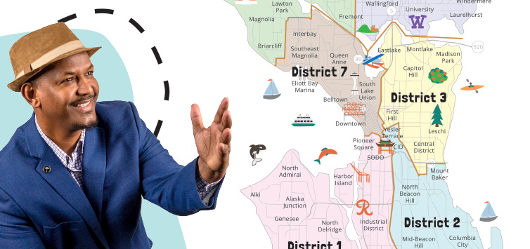
How are the City Council District boundaries changing?
- District 1 currently includes all of West Seattle, White Center, and South Park. With this change, District 1 boundaries are expanding east and north to include Georgetown, the Industrial District, SODO, and Pioneer Square.
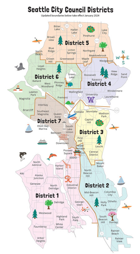
- District 2 currently encompasses Seattle’s southeast neighborhoods, including Rainier Beach, Othello, Columbia City, Beacon Hill, Georgetown, the Industrial District, SODO, and a portion of Mount Baker. With this change, District 2 boundaries are expanding to the north to include Chinatown International District (CID), Yesler Terrace, and the entirety of Mount Baker. Georgetown, the Industrial District, and SODO are moving to District 1, so they will no longer be in District 2.
- District 3 currently includes the Central District, First Hill, Capitol Hill, Madison Park, Yesler Terrace, Montlake, and part of Chinatown International District. With this change, District 3 will now include the entirety of the Eastlake neighborhood. Yesler Terrace and Chinatown International District are moving to District 2, so they will no longer be in District 3.
- District 4 currently includes the University District, Wallingford, Roosevelt, Sandpoint, and parts of Fremont and Eastlake. With this change, District 4 boundaries are expanding north to include Wedgwood. The entirety of the Eastlake neighborhood will be moving to District 3, so it will no longer be in District 4.
- District 5 is the northernmost City Council District. It currently includes Greenwood, Northgate, Lake City, and Bitter Lake. With this change, District 5 boundaries are expanding southwest to include all of Carkeek Park and parts of Blue Ridge and Crown Hill.
- District 6 currently includes parts of Fremont, Green Lake, Phinney Ridge, Loyal Heights, and Ballard. With this change, District 6 boundaries are expanding to include West Magnolia.
- District 7 will now only include Seattle’s Downtown core, Belltown, South Lake Union, Queen Anne, Interbay, and Southeast Magnolia. West Magnolia is joining District 6 and Pioneer Square is joining District 1, so they will no longer be in District 7.
Find your City Council District and learn more about the new District boundaries at https://www.seattle.gov/neighborhoods/about-seattle/neighborhoods-and-council-districts.
If you have questions, please contact Elsa Batres-Boni at Elsa.Batres-Boni@seattle.gov or (206) 256-6198.